
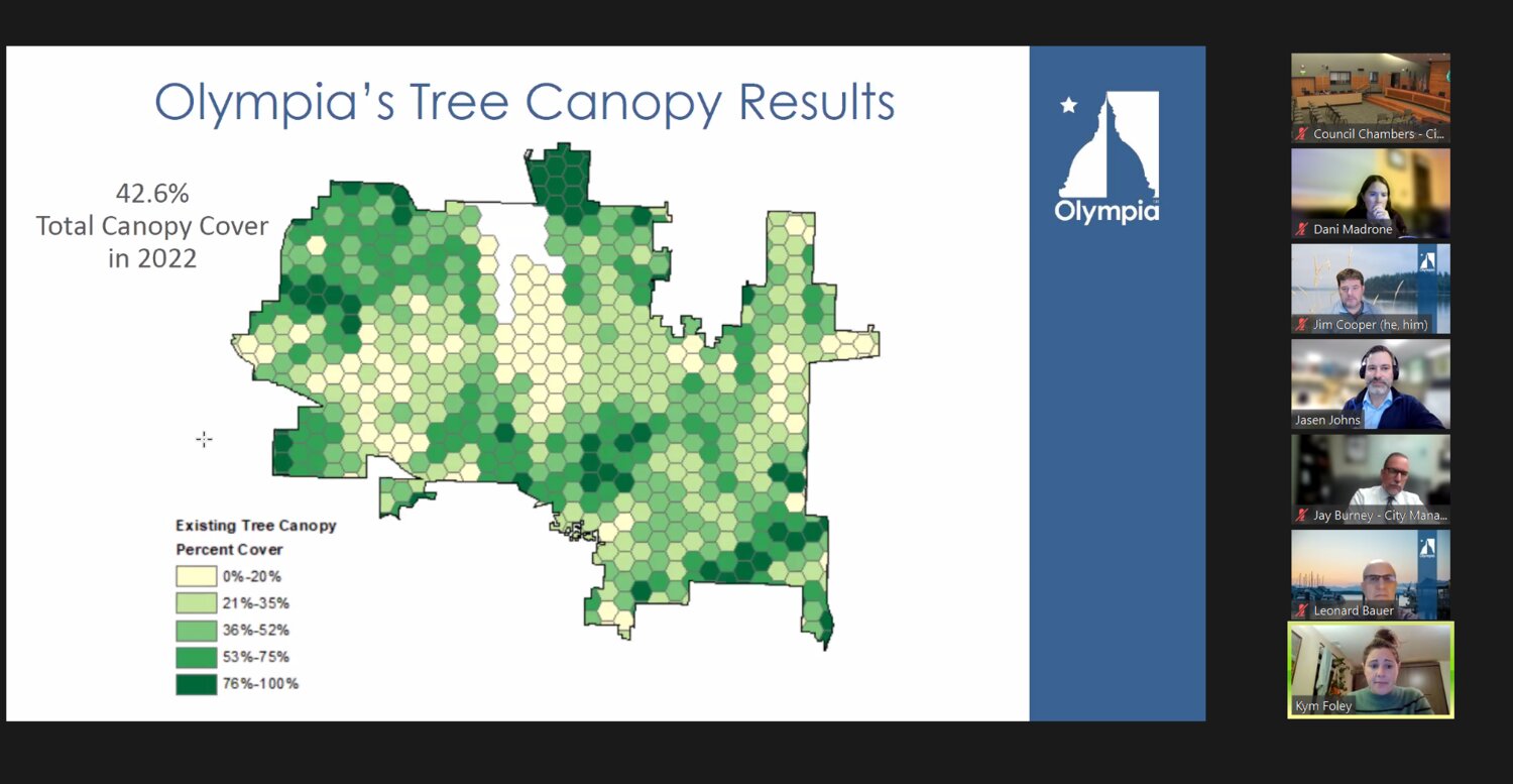
Olympia has tree canopy coverage of 42.6%, reflecting a decline of approximately 2.7% over the past decade, according to the city's 2011-2022 tree canopy assessment.
At the Land Use and Environment Committee meeting on Thursday, Nov. 16, Olympia's Water Resources – Environmental planner Kym Foley and Urban Forestry Program manager Jasen Johns presented the results of the tree canopy assessment, saying the city is still in a "good spot" and the loss is "not wildly alarming."
"Knowing that we're in a good spot feels good. It is interesting here to consider that we are both losing canopy and gaining canopy," Foley said.
Foley said the city conducted the tree canopy assessment to understand the distribution and benefits of its urban forest.
"There's an increasing suite of science-backed data, showing the environmental, public health, and social economic benefits of trees... it's with this growing base of science that is driving now a lot of decision makers and lawmakers, so we're starting to see more and more legislation calling for cities to map their tree canopy to set tree canopy goals," Foley added.
The environmental planner noted that trees provide benefits like carbon sequestration, stormwater interception, and improved air quality and mental health. However, trees must also be managed alongside infrastructure, utilities, and changing pest and disease threats.
The assessment data will help inform the upcoming urban forest management plan, which Johns said will identify "where we want to go" regarding tree canopy goals and priorities.
.png.jpg)
The city received a grant from the State Urban and Community Forestry Program in 2022 for tree canopy assessment. Foley said they worked with a consultant to do the geospatial analysis.
Foley said the tree canopy assessment involved a county-wide, high-resolution land cover classification project. That utilized various high-resolution datasets, including photographic and LiDAR imagery from sources such as the US Forest Service. By analyzing these different data inputs, the project was able to accurately map and classify land cover features such as tree cover, buildings, roads, and other land types across Thurston County.
In her presentation, Foley provided more details about the results of the tree canopy assessment. Through LiDAR data, she said they identified where trees are located and captured information like individual tree heights.
In the 10-year timeframe, Foley said the city lost 2.7% of its total canopy coverage, but the assessment found the loss over the past decade to be just under 3%.
Foley noted that there is a perceived sense that the city had lost a tremendous amount of tree canopy in the last five to eight years. She added that many municipalities aim to reach 40% canopy coverage, but Olympia has already surpassed that at 42%.

Foley said the focus will be on preservation to avoid losing more of the tree canopy.
Foley provided examples in analyzing gains and losses around southwest Olympia, specifically on Automall Drive, Percival Canyon. She pointed out that large canopy losses were visible from a new subdivision development that removed a chunk of trees all at once.
However, the map also showed gains from new street tree plantings dotted along Automall Drive. Foley noted it is helpful to view changes at this localized scale to understand where in the city shifts in tree cover, such as concentrated losses from developments versus scattered gains through other means.
In the northeast neighborhood – Puget and Bigelow, Foley said the canopy losses appeared much more scattered throughout the community than concentrated in one location. She explained that this was often due to trees on residential properties, like those in people's backyards.
However, Foley also noted that this neighborhood experienced significant gains in tree cover, similar to the scattered losses. She pointed out that the distribution and nature of changes could differ between areas.
Foley's presentation also showed how different land use zones aggregated the tree canopy data. She explained that this was done to understand tree cover patterns and assumptions, such as an expectation of less tree cover in commercial and industrial areas.
Her presentation highlighted the stormwater utility's role in initiating the tree canopy assessment. Understanding the relationship between tree cover and surface water flows will continue informing the city's stormwater management and permitting as requirements around urban forestry increase.
"Just a recap: 42.6% tree canopy cover where we are losing tree canopy overall. But in the grand scheme of things, it's not wildly alarming. But moving forward, we will be thinking about strategic tree preservation," Foley said.
Foley explained that the tree canopy assessment would help the city analyze where to focus tree benefits, such as critical habitat areas, and where development may be possible while still providing tree cover. She noted that scaling up tree-planting programs could help offset annual canopy losses.
The environmental planner said the ultimate goal of the assessment is to develop an urban forest management plan that would take a holistic look at tree-related policies, management actions, and recommendations across the city departments. It would incorporate the tree canopy assessment baseline and use public engagement to help identify priorities. The city aims to apply for another grant from the DNR urban forestry program in January to fund initiating the management plan process. Foley hopes to present further on this plan once the grant application is submitted.


1 comment on this item Please log in to comment by clicking here
KatAshe
I’ve always wished that developers were required to add two trees on each lot they develop. I can’t imagine living without trees. Since moving to the Nottingham division in 1997, I’ve seen first a development on Boulevard behind my house where a large number of trees were removed to develop, then a large property on Log Cabin where the developers removed the trees on a heavily wooded property. Very sad.
Tuesday, November 21, 2023 Report this